TWDB FWF
Cameron and Willacy Counties, Texas
RATES was the technical lead for this Texas Water Development Board (TWDB) Freshwater Flows (FWF) project to characterize flow and water quality of four Lower Laguna Madre Tributaries. The project involves the operation of continuous monitoring stations on each tributary to measure hydrologic parameters in combination with quarterly monitoring events to characterize flow and water quality. Data will be applied to address management of hydrologic flows to ensure the health of the ecologically sensitive hypersaline Lower Laguna Madre. Real-Time Hydrologic Stations (RTHS) stations commissioned through this project have been included in the Lower Rio Grande Valley-Regional River and Estuary Observatory network that is being implemented as part of the LRGVDC Regional TWDB Flood Infrastructure Fund project.
Background
RATES’s scope of work for this project included: the establishment of four monitoring locations, one along each of the four major drainage pathways serving the Lower Rio Grande Valley (LRGV) region –the Raymondville Drain (RVD), Hidalgo Willacy Main Drain (HWMD), International Boundary Water Commission North Floodway (IBWCNF), and Arroyo Colorado River (ACR); the development of a Quality Assurance Project Plan (QAPP); the installation, operation, and maintenance of Real-Time Monitoring Stations (RTHS) at the four sites; the performance of in situ sampling and measurement campaigns, conducted once during each of six successive quarters (i.e., approximately every three months) at each of the four locations, including a) collection and processing of in situ data to obtain discharge and selected water quality parameters, b) sampling and subsequent laboratory analysis of additional water quality parameters, and c) quality assurance / quality control (QA/QC) activities; reporting of all data and metadata to TWDB.
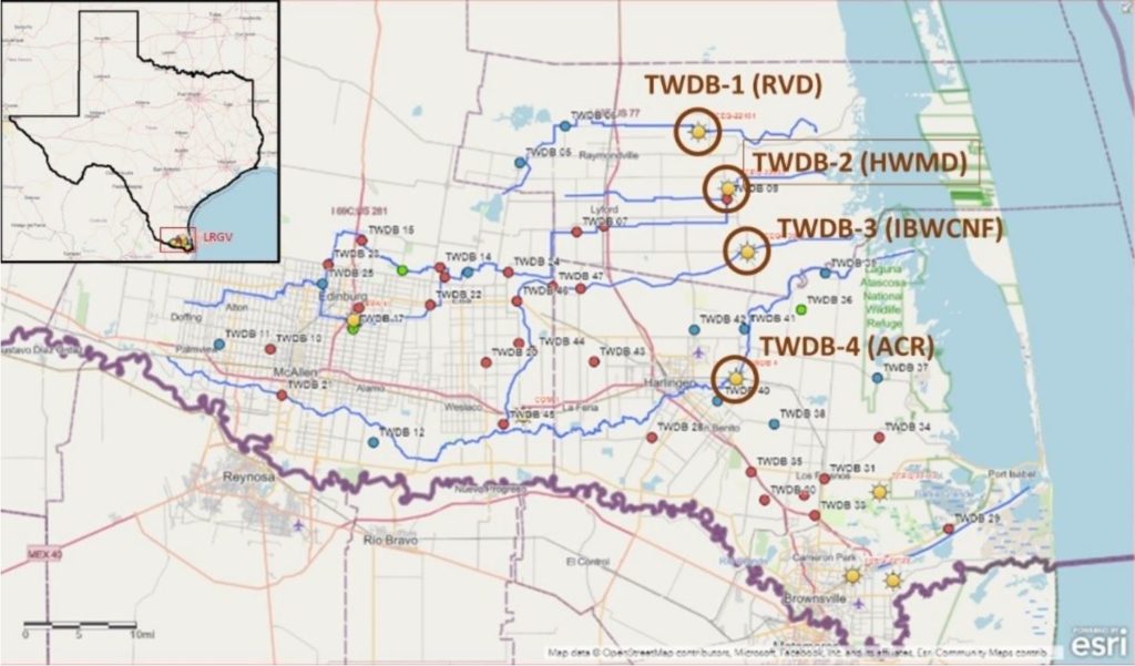
Figure 1. Map of REON-RGV RTHS locations. Brown circles/labels show the monitoring sites for this TWDB-FWF project. Blue lines show major drainage pathways. Insert shows the location of the map within Texas.
Data Collection and Management
Autonomous Real-Time Monitoring
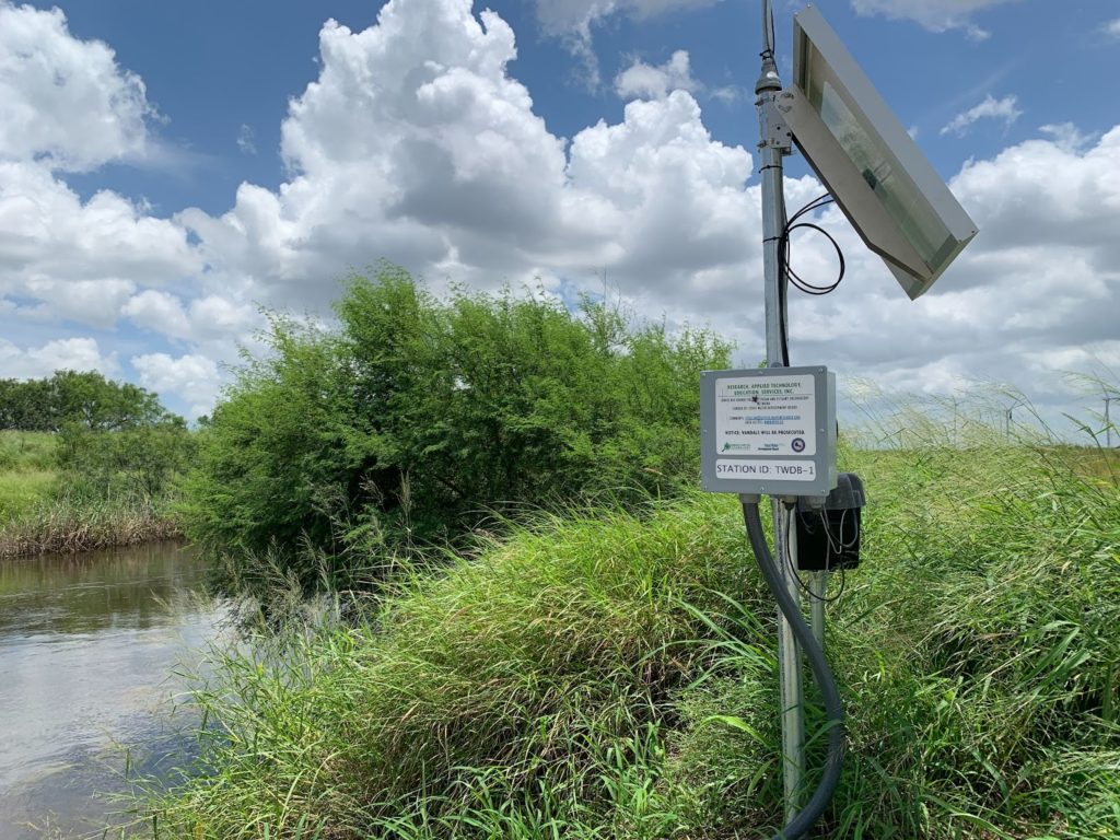
RATES installed four RATES-designed Real-Time Monitoring Stations (RTHS), one at each monitoring site; RATES has since integrated these stations into the regional River and Estuary Observatory Network (REON-RGV) (Figure 1) developed under a separate TWDB-funded Flood Infrastructure Fund (FIF) project. Each station is configured to report continuous real-time gage height (corresponding to a visual staff gage installed at each site) and water-surface elevation (relative to the North American Vertical Datum of 1988 (NAVD88)). Stage heights were measured via a combination of a barometric pressure sensor and a submersed water pressure sensor which are used along with RATES’s Surface Water Elevation/Level (SWELL) system (Kirkey et al, Journal of Environmental Informatics Letters, v4, n2, 2020) to compute the sensor’s depth below water surface. Additional surveying activities conducted at each station enable this depth to be automatically converted to the reported parameters. A permanent survey monument was installed at each site to establish vertical control points necessary for reporting water surface elevations. Monument elevations were surveyed using static data collection; this data is then used to add the monument to the NOAA Online Positioning User Service (OPUS) database. A visual staff gage was also installed at each site, enabling visual verification of the reported gage height for quality assurance purposes; the reported gage height is obtained by adding an offset to the reported sensor depth, such that its reported gage height corresponds to the visual gage reading. Visual gage elevations were obtained via survey against the OPUS elevation of the local monument using Real-Time-Kinematic (RTK) equipment; the gage elevation is added to the reported gage height to obtain the reported water-surface elevation.
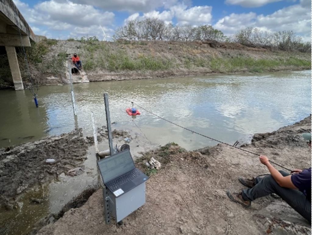
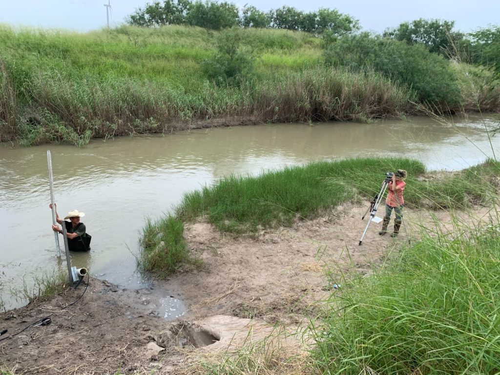
Figure 2. Data collection using EXO2 sonde and StreamPro ADCP at TWDB-1 on April 20,2023
Management and Reporting of Data
Continuous monitoring data from each RTHS was automatically uploaded to the RATES-owned REON cyberinfrastructure, where it is stored in an Observations Data Model (ODM) database along with visual gage readings made during site visits. This data is accessible for viewing and download via http://rths.us/reonrgv.cgi. Examples are shown in Figure 3; these show that TWDB-4 water levels are dominated by tides, while water level at the other three stations are strongly and similarly impacted by local precipitation events. This data was submitted to TWDB in tabular format on a quarterly basis, and resubmitted in full at the conclusion of the project together with a metadata report describing all datasets and explaining any gaps. The in situ measurements from the quarterly campaigns were submitted to TWDB in tabular following each campaign together with pertinent documentation including field notes, EXO2 calibration reports, WinRiverII files, chain of custody records, laboratory results, and photographs.
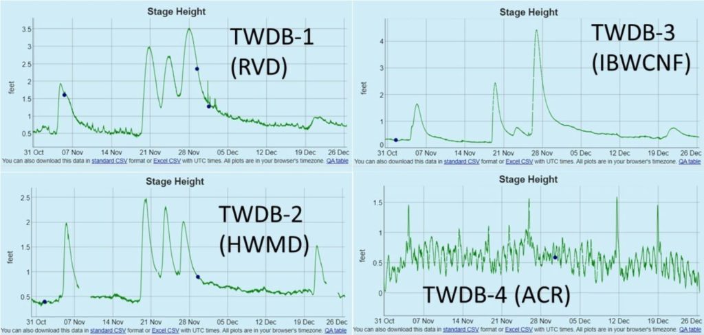
Figure 3. Online visualization of database-stored stage height data from 10/31/2021 – 12/26/2021 for the four sites. The green line shows the RTHS-reported water level; the blue points show readings of the visual staff gage made during site visits.
Data Characterization and Applications
The general purpose of this project (as stated in the RATES scope of work) was for “collecting basic water quality data and water level at sites along the southern Texas coast for use in hydrodynamic modeling and assessment of bay and estuary health.” RATES conducted assorted analyses of the collected data in furtherance of these goals, which are now being accomplished through separate projects with the aid of data and analysis from this project.
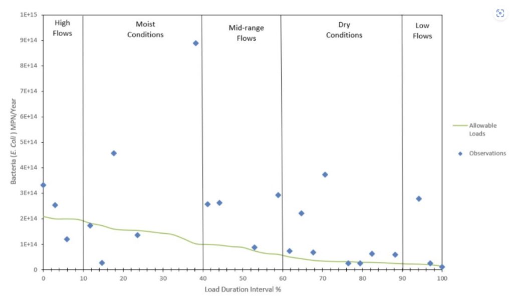
Figure 4. Load Duration curve developed for E. coil in the IBWCNF using data from samples at the TWDB-3 location.
During this project, discharge data collected was used to create stage-discharge rating curves for stations TWDB-1, TWDB-2, and TWDB-3, which RATES has used to compute continuous discharge data from the collected water surface elevation data. (At TWDB-4, discharge cannot be directly correlated to stage due to the substantial tidal impact on water level.) This continuous discharge data has been used to inform hydrologic modeling efforts conducted for the aforementioned FIF project, which is focused on producing data and models to support regional flood control initiatives. The FIF project includes funding to install acoustic current sensors at stations in tidally-influenced waters, such that discharge can be computed from continuous current data via index-velocity methods.
Water quality measurements for these freshwater and estuarine systems indicate that non-point source contaminants (nutrients and pathogens) routinely exceeded Texas Commission on Environmental Quality (TCEQ) Surface Water Quality Monitoring Information System (SWQMIS) nutrient screening levels and contact recreational use concentrations for pathogenic bacteria.
Contaminant sources include runoff-derived sediment loadings from agricultural and urban areas. This data characterization suggests chronically poor water quality. The data and RTHS stations from this project are now being leveraged for environmental conservation via an ongoing TCEQ-funded RATES project to develop a U. S. Environmental Protection Agency (EPA) Nine-Element Watershed Protection Plan (WPP) for three of the region’s sub-basins. This WPP will incorporate best management practices to minimize NPS loads to these freshwater and estuarine systems that may be associated with sediment runoff, on-site sewage facilities, land use practices, and urban development.