![]()
![]()

![]()

![]()


Project Kickoff: Costal Management Program 27 Project of Special Merin-Lower Laguna Madre Hydrodynamic Characterization
Cameron County, Texas (project lead) and RATES, Inc. are proud to announce the kickoff of Coastal Management Program Cycle 27- Project of Special Merit CMP27, Lower Laguna Madre Hydrodynamic Characterization, funded by the Texas General Land Office. This data collection project will augment the Lower Rio Grande Valley’s expanding RATES’ River and Estuary Observatory Network (REON) and fill data gaps, with respect to Lower Laguna Madre’s 3- dimensional circulation patterns and coastal boundary conditions, in coast wide programs including: TCEQ Watershed Protection Plans; TWDB-Integrated Flooding Framework; TWDB-Freshwater Inflows; and TWDB- Flood Infrastructure Fund; and USACE Coastal Resiliency efforts. Advances in these programs, made possible through this project, will enable informed decision processes, and thus ensure the resiliency of Lower Laguna Madres ecosystems services for example: coastal storm protection; maritime transportation; and valuable recreational and commercial fishery.
Data collection activities will include a combination of continuous and event based (quarterly) data collection programs to determine LLM hydrodynamics as a function of seasonal variability and episodic events. Both programs will measure water velocities and water (quality) using Acoustic Doppler Current Profilers (ADCPs) and Conductivity Temperature Depth (CTD) sensors. Continuous monitoring will be conducted at four (4) established NOAA tide stations a two (2) newly installed Real-Time-Hydrologic-System (RTHS). Six (6) quarterly sampling events will involve vessel-based surveys to characterize the spatial and seasonal variability of hydrodynamic parameters.
This CMP-27 PSM provides funding to operate the monitoring systems for 18 months. Continuation of this monitoring program is pending stakeholder support and identification of future funding sources.
_______________________________________________________
Rates’s Principal Investigator
Christopher Fuller, Ph.D.
Chief of Operations
Research Applied Technology Education Services, Inc.-Rio Grande Valley
(RATES-RGV)
P.O. Box 697
Edinburg, TX 78540
Mobile: 518-570-4078
email: cfuller@office.ratesresearch.org
_______________________________________________________
Rates’s Project Manager
Skyler LeVrier
Project Engineer
Research Applied Technology Education Services, Inc.-Rio Grande Valley
(RATES-RGV)
P.O. Box 697
Edinburg, TX 78540
Mobile: 361-739-0314
email: slevrier@office.ratesresearch.org
_______________________________________________________
CMP27 Partners
TWDB, Texas Water Development Board
TGLO, Texas General Land Office
TCEQ, Texas Commission on Environmental Quality
USACE, United States Army Core of Engineers
USGS, United States Geological Survey
NOAA, National Oceanic and Atmospheric Administration
Cameron and Willacy Counties
__________________________________________________________________________
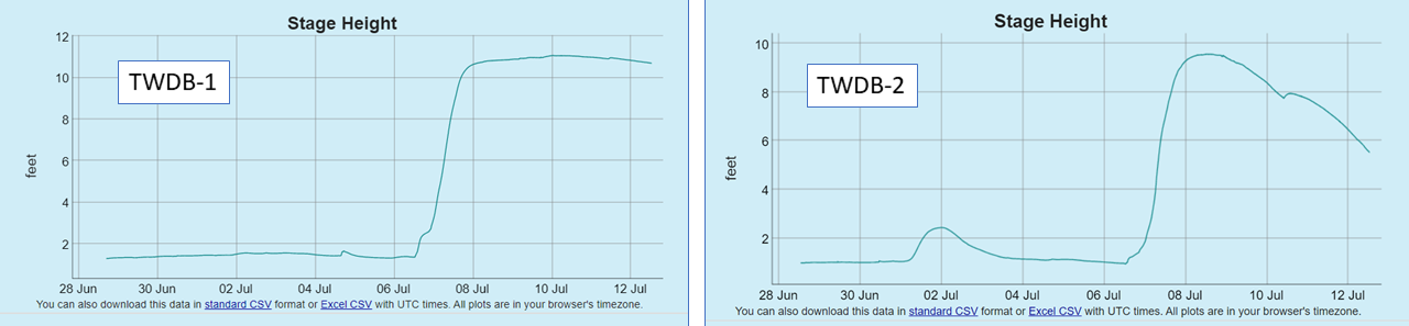
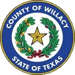
TWDB Freshwater Flows Project- July 12, 2021
In late June, RATES completed installation of the first two of four RTHS stations for the TWDB-funded Freshwater Flows project, both in Willacy County. Station TWDB-1 is monitoring the Raymondville Drain, and station TWDB-2 is monitoring the Hidalgo-Willacy Main Drain. On July 6-7, the region received significant rainfall; airports in McAllen, Harlingen, and Brownsville, respectively recorded 2.11, 4.63, and 5.07 inches of precipitation over the two days. The resulting surge in stage height was recorded by the water level sensor systems at both stations.